OptiPEX & Autonomous Mobility
Leading EU-funded work on last-mile delivery and pedestrian safety around autonomous vehicles

- 2
- IV 2025 papers
- Lead
- EU project technical coordination
Context
In the OptiPEX project, the goal is to optimize passenger experience onboard public transport systems and improve pedestrian safety in shared spaces. Being the technical lead of this project, I develop methods to communicate with and localize pedestrians using UWB technology, which is then fused with AI/ML-based pedestrian detection. I also manage the development and deployment of AI models that detect the occupancy level of individual compartments, enabling smarter public transport.
Locating pedestrians with ultra-wideband
A vehicle in a shared space has to know where the people around it are, and vision alone is a fragile way to find out: it struggles with occlusion and depends on lighting and weather. The strand I lead uses ultra-wideband to close that gap. UWB ranges by timing very short pulses rather than by measuring signal strength, so it degrades gracefully where narrowband radio and GNSS do not - it is far less disturbed by multipath in the reflective urban environments where shared spaces actually exist, and it does not depend on a clear sightline the way a camera does. This line of work follows on from our IV 2025 studies.
Two things follow from that, and both are the work:
- Communicating with the pedestrian, not just detecting them. UWB is a two-way radio link as well as a ranging method, which makes the pedestrian a participant in the exchange rather than a passive object being observed.
- Fusing UWB ranges with AI-based pedestrian detection. Neither source is sufficient alone. Vision gives rich context and classifies what it sees but fails under occlusion and poor light; UWB gives a robust range to a device under exactly those conditions but knows nothing about the scene. Fused, each covers the other’s failure mode.
I evaluated three promising methods for pedestrian localization - GNSS, Bluetooth channel sounding and UWB - in the study below.
What the measurements showed
We benchmarked the candidate technologies against each other on a Clearpath Husky A200 carrying two UWB evaluation kits, a Bluetooth 6.0 kit and a GNSS receiver, with an RTK-corrected GNSS fix as ground truth. Twelve experiments ran across three environments - open ground, a built-up area, and a roofed area with limited line of sight to the satellites - measuring the robot-to-pedestrian distance, including runs where the pedestrian was deliberately occluded.
Distance RMSE, in metres:
| Environment | Smartphone GNSS | Bluetooth 6.0 | UWB |
|---|---|---|---|
| Open ground | 14.68 | 0.72 | 0.23 |
| Built-up | 17.31 | 1.39 | 0.51 |
| Roofed, limited sky view | 20.76 | 2.01 | 0.63 |
Smartphone-based location, with 15 to 21 metres of error, is useless for deciding whether a vehicle and a pedestrian are about to occupy the same space. UWB stays inside a metre in every condition tested, and holds up under the roofed case that degrades GNSS most, which is exactly the geometry of the covered stops and station approaches this work targets.
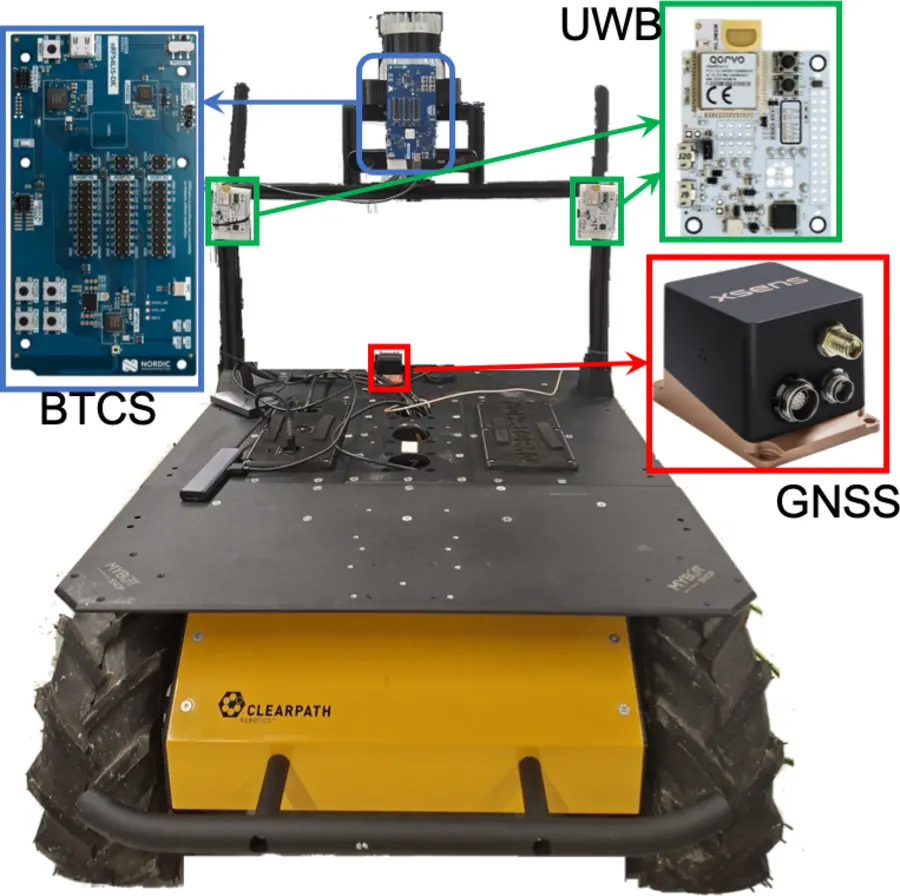
Published as Assessing Localization Technologies for Pedestrian Collision Avoidance at the IEEE Intelligent Vehicles Symposium (IV 2026) in Naples - arXiv:2605.18295.
Onboard occupancy detection
Knowing how full each carriage is lets passengers board the right one when the tram arrives. The approach here uses CSRNet - a crowd-counting architecture that regresses a density map rather than detecting individual people, which is what makes it workable in a packed compartment where bodies occlude one another and person-by-person detection degrades fastest.
My role on this strand is technical coordinator and systems expert:
- Coordinating the data collection campaigns that produce footage representative enough to train against.
- Running the labelling effort that turns that footage into usable training data.
- Ensuring GDPR compliance throughout - an unavoidable constraint when the training data is video of identifiable passengers in a public space, and one that shapes what can be collected and retained before any model design question is reached.
- Evaluating Jetson platforms for deployment, since the model has to run on the vehicle within a fixed power and thermal budget rather than in a data centre.
Running AI models on real-world systems means overcoming significant regulatory and hardware constraints, not just technical ones. What can lawfully be recorded determines the training set, and what fits on the embedded platform determines which model is deployable at all - and those are as much a part of my work as the development itself.
Coordination
Beyond the research, the role is substantially about alignment: OptiPEX spans research groups, industry stakeholders and public transport innovation initiatives, and technical coordination means keeping those interests pointed at the same deliverable.